The original Red River Floodway was built between 1962 and 1968 and cost $63 million. At the time, excavation of the floodway channel was the second largest earth moving project in the world (second only to the Panama Canal and larger than the Suez Canal project). Since 1968, it has prevented more than $40 billion (in 2011 dollars) in flood damage to Winnipeg.
The floodway operates by diverting a portion of the Red River flow around Winnipeg through the floodway channel. During flooding, as the river naturally rises, it spills over the floodway channel entrance and flows down the floodway channel. When this happens, the river water flows through two routes – through the city and through the floodway. At the same time, it drops below its natural level, south of the floodway inlet (Province of Manitoba – Floodway).
The floodway gates were put into operation in 1967, a year late for the 1966 flood. The gates can be viewed by approaching from Turnbull Drive on the west side of the Red River or Saint Mary’s Road on the east side. What you see from ground level is what looks like a fairly ordinary bridge. A control and lookout structure exist on the south side of the bridge. From inside it is a different story. Buried some sixty feet below the surface are the gates and mechanisms that make them work. To reduce the flow of water through the city and redirect it into the floodway channel the gates are raised from below.
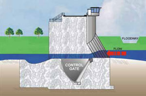
Floodway gates during normal conditions
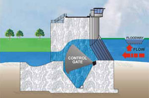
Floodway gates raised to regulate water levels
When the floodway gates are raised, the water level south of the floodway inlet is restored to its natural level which, in turn, allows more water to spill into the floodway. As Red River flows continue to increase, the level south of the inlet drops below natural again and the gates are raised further. This process continues as long as the flow in the Red River continues to increase.
The following photos were taken by Peter Loewen in 2012 when one of the two sets of gates had been drained of water so that repairs could be made. You can see the curved gate on the right of the pictures. Raising the gates is assisted by the force of the water on other parts of the structure. At the point where the photos were taken he was some fifty feet below normal water levels.

Floodway gates under construction

Floodway gates under construction
Sources and More Information
St. Norbert Heritage Park Floodway Trail
Red River Floodway Expansion Project Newsletter (PDF)
Manitoba Historical Society – Duffs Ditch
CBC Digital Archives – Duffs Ditch is Completed (Video)
CBC Digital Archives – The Winnipeg Floodway (Video)
CBC Digital Archives – Topic: Manitoba Floods
RM of Ritchot Artificial Flooding Study (PDF)
Province of Manitoba – Flooding Information